Way back in June, through America’s Great Loop Cruisers’ Association, we were contacted by MacLean’s magazine. They were interested in Canadians who were doing the Great Loop during the world pandemic.
First, we had a telephone interview with the reporter, and, once we arrived in Canada, a face to face interview. Then, on a very rainy day, a photographer came to the boat at Rideau Ferry Harbour. Now, the story is published – what a thrill to read about our story, and the story of our friends on Red Dog, through someone else’s words!
After over 14 months (two months longer than planned and including two weeks in quarantine) our Great Loop adventure has come to its completion. We cruised into Rideau Ferry Harbour on Tuesday, August 25 shortly after 8:00 a.m. So good to be home and to hoist the Gold Looper flag!
We are officially ‘Gold Loopers!’
We celebrated that evening with a small group of family and friends.
Witnesses to the hoisting of the gold flag.
It is so great to be together again with family!
Our son and grand-daughter enjoying a beautiful day on the water on August 31, 2020.
We tried to keep busy during our two-week quarantine; one of the things we did was calculate some of our trip statistics. Some people like statistics and some people don’t – I hope you won’t find this too wearisome!
We travelled a total of 10,196 kilometres (6,335 miles) or 843 engine hours. For comparison, in a normal summer season we do about 100 engine hours.
Cruising into Chicago in September 2019.
We visited three countries.
Canada: Campbellford is home of the giant twonie – July 1, 2019.United States: St. Louis, Mississouri – September 23, 2019.Bahamas: our first Bahamian sunset – January 1, 2020 – on our way to Bimini.
In the United States, we visited a total of 18 states. Each state has its charms but for scenery, we thought the best was in Tennessee. My log book on October 8, 2019 states: ‘we went through the Nickajack Lock by 8:00 a.m. and then proceeded to have the most scenic cruise since we left the North Channel on Lake Huron in Ontario’.
Tennessee River, October 8, 2019 – not far from Chattanooga.
Since we are located on the Rideau Canal we are well used to locks and we knew we were going to do a lot; our grand total: 146. Our favourite was actually not a lock at all: Big Chute Marine Railway on Trent Severn Waterway in Ontario.
Gyp C on the Big Chute, Trent Severn Waterway, Ontario – July 15, 2019.
A close second was also on the Trent Severn Waterway: the Peterborough Lift Lock.
When completed in 1904, the Peterborough Lift Lock was the highest hydraulic lift lock ever built with a vertical lift of 65 feet.
We didn’t calculate how many bridges we went under – but it was a lot!
Calumet River, near Chicago – September 11, 2019.Waiting for a bridge to open on the Tombigbee River, Alabama, November 16, 2019 (with our friends on DougOut).
We anchored 117 times – some remote…
Croker Island, North Channel, Lake Huron, July 28, 2019.
…some not so remote.
Sunrise Bay anchorage, Fort Lauderdale, Florida, December 23 to 31, 2019.
We stayed 263 nights in marinas – some we don’t even remember and some we stayed so long we will never forget. Marina stays were our biggest expense. Although we stayed one month at Ocean Reef Marina in Lucaya on Grand Bahama Island and five weeks at Shady Harbor Marina in New York, it was the shorter stays that added up to the greatest cost.
Tarpon Springs Municipal Marina, November 29, 2019. Jacques (with Lynne, not pictured) is making a communal spaghetti sauce on the dock between our two boats (Gyp C on the left, DougOut on the right). There was enough to fill 20 mason jars. Yum!We felt dwarfed at Marina Jack’s Marina in Sarasota, Florida December 4, 2019. We are the front boat on the left. We only stayed one night as it was very expensive but Sarasota was a very interesting stop.
We stopped a total of 32 times for fuel. Total fuel: 15,479 litres (4,089 gallons). Fuel burn 1 ½ miles per gallon. Cheapest fuel: $1.50 per gallon (at two locations: Myrtle Beach, South Carolina and Portsmouth, Virginia). Most expensive fuel: Palm Cay Marina near Nassau, Bahamas $3.82 per gallon. Average price $2.74 per gallon.
While laundry was not our biggest expense, it seemed like I inserted hundreds of quarters into washers and dryers (I really missed loonies and twonies!). Most expensive laundry: $11.50 in Bimini, Bahamas (that included wash and dry thank goodness). Least expensive: free – at select marinas. Most common: $1.50 per wash, $1.00 to dry.
We were expecting restaurants might have been our biggest expense as Looping is a very social activity. The world pandemic effectively curtailed our restaurant spending. We rarely ordered out from March 13 to May 15 – the day that patio dining began to be available in Virginia. Best restaurant meal on the Loop: Di Salvo’s Bella Cucina, an Italian Restaurant in Parry Sound, Ontario. Best pizza: Great Harbour Cay Marina in The Berry Islands, Bahamas. Best view: Boathouse Grille at Shady Harbor Marina.
Shady Harbor Marina, Hudson River, New York. Photo credit to Diane Grabo.
We had a few new food experiences. In Canada: wild boar (at that restaurant in Parry Sound). In the United States: hushpuppies (a fried dough concoction), oysters, crab (including soft shell crab), okra, southern boil (a stew comprising of sausage, shrimp, potatoes, corn on the cob all boiled together in one big pot). In the Bahamas: conch (we didn’t like conch salad, but loved conch fritters).
Conch salad.
We enjoyed seeing the wildlife. We found the American Pelican not the prettiest bird, but it fascinated us. It is beautiful when flying and amazing when dive-bombing for fish.
Fort Pierce City Marina, Florida, March 14, 2020.
We were delighted with the dolphins which we started to see near Mobile Bay in Alabama. We would count that as one of the highlights of our trip.
Dolphins liked travelling with us both at the bow and at the stern of our boat.
We could have done without the Asian Carp, but that is one of the stories of our Loop (one jumped over four feet and landed on our boat). Sadly no picture.
The most northerly spot we went was Sault Ste Marie in Ontario (right on Lake Superior). Staniel Cay in the Bahamas was our most southerly point. West was Grafton, Illinois and East was Waterford, New York.
By chance the hottest and coldest temperatures we endured were on the Tennessee River. We had a crazy heat wave from Sept 28 to Oct 3, 2019; even swimming in the river was not refreshing – it was like jumping into a hot bath. On November 1 at Florence Harbor Marina there was enough frost on the boat to make a snowball. We also had very cold temperatures on Nov 14 and 15 on the Tombigbee River in Alabama; luckily we were travelling with our friends on DougOut and they had an extra propane heater which we used on the flybridge while cruising.
Here I am dressed for locking on November 8, 2019 going through Stennis Lock, near Columbus, Mississippi on the Tombigbee River. It was 5 degrees Celsius with a bitter wind.
The strongest wind was at Staniel Cay in the Bahamas: sustained winds of 72 kilometres an hour.
This picture was taken at about 6:30 a.m. on February 2, 2020 after a night of being awake and keeping watch on the anchor. There were over 70 boats (of all sizes) anchored.
Lake Michigan (fondly called Lake Washing Machine by Loopers) had some pretty nasty winds as well.
Break-wall near Reef Point Marina, Racine, Wisconsin. August 24, 2019 – a good day to be docked at the marina.
We didn’t leave the boat often; only nine days in total. Seven days in late August for my mother’s 90th birthday; one day in December to visit our friends on DougOut in The Keys; and one night in late February at my brother’s rental condo in Lucaya, Bahamas.
Coral Beach, Lucaya, Grand Bahama Island
When asked what the best part of our Loop is, we don’t really have to think too hard – it is the people. We have made some lifelong friends – both Canadian and American.
Lynne and Doug (with Archie), Ingram Bay anchorage on the Gulf Intracoastal Waterway, November 18, 2019.
We also met people who, though we will likely never see again, left a lasting impression due to their generosity and kindness to total strangers.
Our neighbour, Bob, at Reef Point Marina, Racine, Wisconsin lent us his car so we could pick up groceries.
The trip wasn’t all smooth. Obviously there were some disappointments: the devastation of Hurricane Dorian caused us to change our Bahamas plans (original plan was to cruise the Abacos). However, this led us to meet some extraordinary people who we wouldn’t have met otherwise. And see some sights we weren’t expecting.
Dolphin House, Bimini, Bahamas. This is a work in progress (since 1993) as it is being built by one man out of recycled materials. We had a fascinating tour here.
A common question we get asked is would we do the Loop again. While we don’t expect to do the Loop in its completion again, we definitely will return to Georgian Bay on Lake Huron. It is so beautiful there and the water is pristine. You could spend several summers there and still not experience it all. We are lucky that it is practically in our backyard (only a two week cruise away).
Georgian Bay, not far from Parry Sound.
While we saw a lot of beautiful scenery on the East Coast of the United States, we did miss seeing some interesting places due to the world pandemic. Too soon to tell, but a trip down the East Coast could be in our future plans.
Cruising through Georgia, early April 2020
Some things we learned. There are more nice people in the world than not nice people. We know more about boating than we did before the trip including: how to figure out weather, wind, currents and tide and when all four are involved how to maneuver that. We learned about geography and history. The biggest thing we learned is that we can handle ourselves in messy situations and that we still like each other after over a year of living on a boat! We make a great team!
Freeport, Bahamas.
And so our journey is ended. We will never forget it and we have so many memories.
After three days in the village of Phoenix, we set off up the Oswego Canal on Sunday, August 9. Ultimate destination – Canada!!
The New York Locks operate from 7:00 a.m. to 5:00 p.m. so we were ready to go very early. We entered Lock 1 with two other boats – a Canadian Looper and an American boat heading to Lake Ontario. Things didn’t go quite as smoothly as anticipated. First, the Bridge Operator was late. The Lock Master was very personable and young and kept apologizing for the Bridge Operator. Finally, the lock started its operation – to take us down 10 feet. About half way down, we started going back up. We were confused and worried – is the lock not going to work after all this time? The Lock Master admitted it was his first time doing a lockage solo – he forgot to close the intake valve. Once he rectified that, we started going down again. But then…the bridge didn’t open! We saw the Bridge Operator in panic mode! The Lock Master and the Bridge Operator started yelling at each other. We start to go into panic mode! Finally, after what seemed like several minutes, the bridge started to open. Whew!
Gyp C cruising between Lock 1 and Lock 2 on the Oswego Canal. Photo credit to Shannon Clear Smith who lives on the canal and keeps an eye out for Loopers. She posted on Facebook that we were the first Looper boat through the Oswego Canal this year.
No issues going through the rest of the locks and we arrived at Lock 6 about 11:30. Two other boats joined us later in the day – both Loopers: one Canadian, one American. In total we were five boats docked at Lock 6 waiting for the next day’s opening.
Last get together of our Loop – celebrating the fact that we would soon be on our way, and lamenting the fact that we would soon be parting ways. To our left: Irene and Rex, Canadian Loopers who we spent a lot of time with at various spots on the Loop, including Christmas in Fort Lauderdale. To our right: Dorothea (taking picture) and Brian of Sequel, also fellow Canadian Loopers who we first met on the Tennessee River and then ran into again at the end of May cruising together on Chesapeake Bay and on the Oswego Canal.
The next day (Monday, August 10 – the day we have been waiting what seems like forever for!) we were raring to go. Everyone was up early. Everything went like clockwork. We were in Lock 6 at 7:25 and out of Lock 8 at 8:15.
The infamous Lock 7 – the one that was holding up the opening of the Oswego Canal.
From Lock 8 we could see Lake Ontario – and it looked nice and calm – we were on our way! We headed to Kingston; the other Canadian boats headed to Trenton.
Leaving Lock 8. Photo credit to Sequel.Leaving Oswego, New York. Lake Ontario, here we come!
We maintained radio communications with the other Canadian boats for a couple of hours but then we were too far away and we were alone. At 11:54 we crossed the border into Canada!
Here is what crossing the border looked like on the chart plotter. The red line is the border.
And here is what crossing the border really looked like.
After so many months of waiting to get back home to Canada we had a couple of thoughts: it seemed a bit surreal and it was almost anti-climactic. Just another day on the water.
Shortly after crossing into Canadian waters, we picked up a stowaway.
This cormorant startled us – he flew so close to the windshield he was just a blur, and then he landed – and stayed for about five minutes. Maybe this was our pre-check for customs!
Although Lake Ontario is very vast, we never lost sight of land; this is Main Duck Island.
Main Duck Island is located in Canadian waters between Oswego and Kingston.
You know you are in Kingston when you see a Martello Tower.
After some initial confusion, we had a plan for clearing customs. As we were leaving Oswego, we called the customs number for small craft reporting and were informed the Kingston customs office was closed. We found this hard to believe so we called again and talked to a different agent: she was very helpful, confirming that Kingston was indeed open and she alerted Confederation Basin Marina that we would be arriving in a few hours. Although there were two customs agents waiting for us on arrival, we first had to call the small craft reporting number where we were again informed that we could not clear in at Kingston as that office was closed. Of course, that was news to the on-site agents. Once that was all sorted out, the clearing in process was pretty straightforward. The agents explained that for our quarantine period we would not be allowed off the boat, except as necessary to secure the lines. As our plan is to anchor during quarantine this will not present a problem. They also indicated we could continue travelling while in quarantine, including the Rideau Canal, as locking does not require you to leave the boat.
Our first night in Canada, we anchored not far from Kingston where we enjoyed a peaceful evening.
It is so good to be home!
Although we planned to stay two nights at this anchorage, as sometimes happens, the wind changed the next day and the anchorage became uncomfortable. Late in the day, we decided to head to the first lock on the Rideau Canal, Kingston Mills, to dock for the night. There were no other boats there; Kingston Mills has a reputation of being one of the noisiest locks on the system as the busiest railway crossing in Canada runs right over the lock. In fact, when you are going through the flight locks, the bridge is right on top of you and we can attest that when a train passes overhead when you are in the lock, it is impossible to hear anything else.
Note the train bridge over the lock. We found the night to be very peaceful. While we could hear the trains passing, they were not blowing their whistles and the ‘clickity clack’ on the rails was very comforting. We did have other ‘noise’ though.On our arrival at Kingston Mills, this man was singing his heart out and he kept us entertained for over an hour. Keeping our distance, we didn’t find out who he is but he can sure play the guitar and has a fantastic voice.
The next morning we got underway at 9:00 a.m. It was a beautiful day and everything went smoothly. There are 15 locks to get to our home waters; we completed 11 on Wednesday, August 12. We knew we were getting close to home when we saw and heard our first loon.
We saw this loon between Cranberry Lake and Whitefish Lake.
We headed to one of our favourite anchorages: West Bay on Sand Lake.
This island is located on Sand Lake on the way to the anchorage. The Canadian music group The Arrogant Worms sums up Canada in three words: rocks and trees and water. This picture says it all!
We enjoyed seeing the scenery on the Rideau Canal.
Heading for the narrow channel between Indian Lake and Clear Lake.Anther narrow spot: Murphy Narrows
It is quite a different feeling to go to places you have been before. It feels too easy. We know the waters and we know what to expect. After over a year of every day being a new experience, this feels kind of strange.
We went through The Narrows Lock (our last lock of the trip!) on Friday, August 14 and cruised to Nobles Bay, an area very familiar to us as it is located only a half hour cruise from our home marina in Rideau Ferry.
Early morning at Nobles Bay anchorage.
We have just completed week one of quarantine – one week to go!
After two days in Utica, we set out again on Wednesday, August 5 shortly after 7:00 a.m. We were not the only ones out and about.
Port Jackson tug
After an hour or so of cruising, we came across this dredger right in the middle of the channel. We communicated by radio and he indicated he would move over so we could get by. This is how much room he gave us.
We had to stay on the right side of the white markers. We squeezed by as close as we could. As we went by, we did touch bottom briefly so the channel is definitely in need of dredging. No damage though…phew…
We are feeling very worldly – we passed by Rome.
According to the sign on the bridge, Rome is the copper city.
As it was still early in the day, we debated whether to cross Lake Oneida once we arrived at Sylvan Beach. Easy decision: it was made for us. When we arrived at the lake, it was pretty rough, so we docked at Sylvan Beach for the night.
A bit windy out on Lake Oneida.
The next day, Lake Oneida was looking much calmer so we set off.
After a two hour cruise on Lake Oneida, we are approaching Brewerton, New York.
We were very happy to see this sign.
Only 24 miles to Oswego and Lake Ontario!
Stowell Island was settled in the mid-1600s by the Jesuits. According to legend, the French and the Jesuits were fleeing from the Indians and camped on Stowell Island. To lighten their load, they left behind cannon and gold. Although no gold has ever been found, to this day the locals refer to the island as Treasure Island.
Apparently there is more than one Treasure Island in the world.
We stayed at the village of Phoenix, location of Lock 1 on the Oswego Canal. Lock 1 is home to the Bridge House Brats, a volunteer organization made up of kids from ages eight to 18.
Part of their mandate is to assist boaters. We found them to be very personable, helpful and delightful. On Friday evenings there is live music at the lock and the ‘brats’ act as servers, picking up food at the local restaurants and delivering it to you on the dock.
Here we are with other Loopers waiting for our food delivery from the ‘brats’ (our boat is just in the background).
On Friday, August 7, we finally got the news we have been waiting for: Lock 7 on the Oswego Canal would be opening on Monday, August 10 at 7:00 a.m. We were (and are) ecstatic! Early Sunday morning (August 9) we set off to see how far we could get.
Here we are cruising between Lock 1 and Lock 2 on the Oswego Canal.
We actually got a little further than we thought we would and ended up at Lock 6. The Lockmasters are super friendly – they are as happy as we are! We took a walk and investigated Lock 7 – the one that has been closed all this time. It does indeed look ready and the staff at Lock 6 confirm it. So it must be true!
Lock 7 looks ready!
We will do our final weather checks just before leaving, but as of now, it looks like we will continue through Locks 6, 7 and 8 and then cross Lake Ontario on Monday, August 10! Now, if we only knew where to go to check in with Customs. We will keep you posted.
Shady Harbor Marina was our home for five weeks. While we enjoyed our stay there immensely, it was definitely time to start moving again. At the Looper farewell get-together on Thursday, July 30, the owners joined us as we said our good-byes to all of our new Looper friends.
Brian and Cathy Donovan, owners of Shady Harbor Marina are serving up Little Beers (there is nothing beer-like about them except that they look like a little beer). They contain a shot of Licor 43, a Spanish liqueur, and whipping cream. We learned that these are a Looper tradition; first popularized here at Shady Harbor Marina.
During our time at Shady Harbor, we met lots of fellow Loopers and formed friendships.
Wayne and Barb: fellow Canadian, fellow Loopers, and fellow curlers!
We finished up a few projects.
An unexpected repair: our dinghy davit/winch broke so we had to have a new one built – here is Jacques installing it.
On Friday, July 31, we said goodbye to Shady Harbor.
Shady Harbor in our ‘rearview mirror’
We continued north on the Hudson River.
Albany, New York
After Albany, we went through the first of 30 locks we will encounter on our way to Lake Ontario.
A welcome site!
This sign is pointing us in the right direction.
Turn left to go to Ontario, turn right to go to Quebec.
We docked at Waterford for one night.
Waterford is the oldest continuously incorporated Village in the United States.
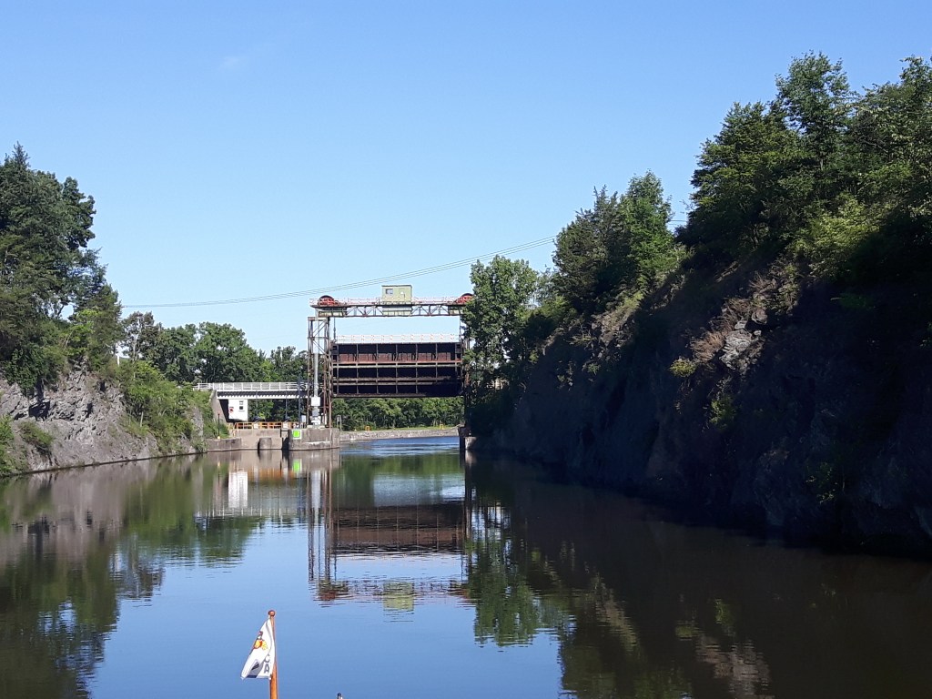
The Erie Canal Locks open at 7:00 a.m., so no sleeping in for us on Saturday, August 1. We were up bright and early, and with three other boats, made our way to the Waterford flight locks. The Waterford Flight locks have the highest combined lift on the Erie Canal raising you a total of 169 feet over a distance of about 1½ miles.
The original Erie Canal was very different from today’s Erie Canal. It was designed as a ditch filled with water so mules or horses could walk beside the ditch on a towpath and pull the boats through. When the canal opened in 1825, it was four feet deep and 40 feet wide. Here is a link to a song about the Erie Canal.
The sailboat in front of us is doing a lock for the very first time. They had no trouble on the first two locks. But on the third lock, they had an engine issue and crashed into the lock wall – which is made of cement. Needless to say, it was not a pretty sound but their anchor took the brunt of the impact. No damage to the boat.
Guard gates help to isolate sections of the canal in case of emergency, such as a break in the canal wall, accident, or extreme high water. They are also used when a section of the canal needs to be drained for maintenance or winter freeze protection.
Approaching a guard gate.
As you know, locks and dams go hand in hand. The dam below looked beautiful.
Even more interesting was seeing this boat seemingly on top of the dam, however, it is actually headed into the lock located behind the trees.
It is so nice to be back on inland waters.
No tides, little or no current and on this day, no wind!
Way back in November, we were so happy to leave the locks on the rivers. Now, we are so happy to be back in locks! It means we are getting ever so closer to home!
Getting back in the groove of locking.
We keep seeing this tall ship and even went through a few locks with it. It is from Russia and is a replica of an 18th century belomorian boat that was built in 2007. The boat is 43 feet long and 13 feet wide with a displacement of 15 tons. To put this in perspective our boat is 43 feet long and 15 feet wide and displaces 14 tons. This boat has been all over the world, crossing oceans. The captain is Sergey Sinelnik and although different crews join him on board, at times he has his family on board as well. The trip to get here from Russia took three years.
Note the mast has been taken down for passage through the bridges and locks. The captain looks like a grizzled veteran. One of the crew members spoke English and indicated he was quite happy to be on the portion of the trip that was in inland waters; in his words, he was not experienced (or brave) enough to do the ocean portions.
We ran across another wooden boat; not quite the same size.
These guys were sure enjoying their Saturday morning.
It is wonderful to be back on the water and actually go somewhere. We are travelling with fellow Loopers on Seabatical, Christine and Joe.
Seabatical and Gyp C at Lock number 8 on the Erie Canal
On Sunday, August 2, the afternoon weather was looking a little iffy (forecasts for wind and thunderstorms), so we got up extra early to get a very early start. Up at 5:30 – on the move by 6:00.
The Mohawk River is beautiful!And calm too!
We have noted a lot of debris on the canal: logs, branches. This is something we typically see in the spring after the canal is open for the first time. We are seeing it now because some of the locks were just opened a few days ago, so it is simulating spring conditions.
This particular log was providing a resting spot for this cormorant.
As sometimes happens, the weather was not exactly as forecast; it stabilized and we were able to keep moving. We are discovering that docking options on the Erie Canal are extremely limited this year. Of course, partly due to COVID, but also due to a major flood in November of last year where many docks were totally destroyed. After cruising for eight hours (about four hours longer than planned), we finally found a spot at St Johnsville.
Captain having a much-needed nap at St Johnsville Municipal Marina.
Shortly after our arrival, the mayor of this small village arrived at the marina and personally welcomed us. The village depends on the boating traffic for economic benefits and this year has been terrible for them. Dockage is free; you are encouraged to patronize local businesses. The mayor recommended an Italian restaurant and advised us to call them for a reservation (and also a ride!). Sure enough, the owner of the restaurant came to pick us up! The food was great; the service was awesome; the ambiance was homey. At the end of our meal our server drove us back to the marina. Now that’s service!!
On Monday, August 3 we cruised to Utica. Since we arrived shortly after lunch we had the afternoon to do some exploring.
This is the interior of the Utica Train Station. It is over 100 years old and is still in use. The marble columns are breathtaking.
Utica has a great outdoor wall display explaining all of their history. We found the picture below interesting.
The Erie Canal is not located here now; it was moved and enlarged for barges in the early 1900s.
We are tracking Tropical Storm Isaias and so are staying put in Utica for another day. We are far enough inland that we expect to miss the brunt of the storm. We plan to continue making our way to the Oswego Canal in the hopes that it opens on schedule. To say we are anxious is an understatement – we just want to get home!
Even though we are still in New Baltimore, New York, we know we are close to home…as we have been invaded. After about eight months with absolutely no spiders to be seen anywhere on board Gyp C, we have been inundated since our arrival at Shady Harbor Marina. Salt is a natural type of spider poison so since we had a lot of salt on the boat while cruising in ocean waters, there were no instances of spiders or spider webs. Boy, are we making up for it now! We are now far enough up the Hudson River, that even though we still have tides and current, the water is almost fresh. My morning routine includes getting rid of all the spider webs and spiders that have accumulated overnight. While this is something that we are well used to in our home waters on Big Rideau Lake, the spiders seem unusually plentiful here. We have tried various methods to deter them but so far they are a resilient bunch and seem to like our boat (I don’t blame them – we like it too!).
We are still waiting on the New York Canals; while the Erie Canal is now open (ahead of schedule), there has been no change to the planned opening of the Oswego Canal; it is slated to open for through traffic on August 10.
Lock number 7 on the Oswego Canal; looks like progress is being made. Photo credit goes to Barry O’Neill, a member of the America’s Great Loop Cruisers’ Association.
Our days have fallen into somewhat of a routine. Chores in the morning, relaxing in the afternoon. Everybody here is in the same boat (pun intended) waiting for the locks to open.
Recently, for one of the morning chores, I had to be very brave. I hadn’t had a haircut since December; it was definitely time. I made an appointment with a very ‘experienced’ stylist more known for his expertise on mechanical and electrical components. He watched a three minute YouTube video and declared himself ready. As he was snipping away, I heard these disconcerting words: ‘This is just like taking apart a transmission.’ I was afraid to ask what he meant. Apparently it translates to ‘this is the first time I have done this.’
I am still smiling; Jacques did a very good job – taking abut three inches off and getting rid of all the split ends.
The marina comes equipped with horseshoe pits and bocce courts so we have been making use of these to while away the afternoons.
A rousing game of horseshoes.Girls against the guys; the girls were leading the whole game except for the very end when we ‘let’ the guys catch up and surpass us!
When not playing games, we gather in the late afternoons under the big tent and share experiences and stories.
One fine, calm day, we took our dinghies about two miles up the Hudson River for a dinner out.
It was nice to have a change of scenery and the food was good!Though we ate outside on the patio, the restaurant inside was decorated with license plates including one from New Brunswick!
One Saturday, we signed out the marina courtesy van and ventured onto the other side of the Hudson River to visit a farmer’s market in the village of Kinderhook.
We found a pop up restaurant featuring Thai food – it was a nice treat! We enjoyed the day with our Canadian friends Rex, Irene, Wayne and Barb.
I have only seen one foggy morning in the month that we have been here.
Gyp C is on the dock on the left.
Weather permitting, every Saturday night there is a campfire. There is a bit of an artist in charge of setting these up.
He hollows out the logs and builds the fire inside. For this particular fire, he made a happy face.
On Sunday, July 26, the marina held a pig roast which is a fund raiser for the local Boys and Girls Club.
We could smell this cooking all day – it was delicious!
Our plan, as it stands now, is to depart Shady Harbor Marina on August 1 and start making our way through the Erie Canal. We are not the only ones feeling a bit antsy to get going again. We are all hopeful that the Oswego Locks will open as scheduled so we can continue on our individual journeys.
We have been here at Shady Harbor Marina for just over two weeks. On our arrival on Friday, June 26, we noted that they hadn’t any rain for quite a while. Well, we can definitely say that they have had some since we have been here. It either rained or thunder-stormed every day the first week we were here. We were happy to see the first heavy rain – it meant a good cleansing for the boat – removing all that bad salt. And we were happy to see the second heavy rain – another good rinsing.
The view out our side window.
We borrowed a car and went exploring on July 2 with Renée and Pierre of Shoreline Traveller.
Kaaterskill Falls in the Catskills
The Northern Catskills area is one of the earliest vacation destinations in America. In the early 1800s, ‘going to the Catskills’ meant going to the Kaaterskill Region.
On the pathway to Kaaterskill Falls.
We also visited the village of Catskill.
The village is home to a lot of cat statues (and Jacques was happy to find there were two micro breweries in the village where he got to sample the wares).
Later that same day while having dinner at a restaurant, a micro-burst (or mini tornado) passed through the marina. We heard later that the winds were fierce (for about two minutes). One boat has lost some of its canvas. There is a barbeque area at the marina that is covered by a large tent secured with cement blocks; on our return the tent was totally down and the cement blocks had moved a considerable distance. We didn’t waste any time checking out our boat; luckily, we had no damage – just a lot of water in the fly bridge.
After a week of grey, dismal weather, we were happy to see July 4 dawn bright and clear and sunny with no rain, thunderstorms, or other in the forecast! And to top it off, that evening – a beautiful full moon.
Photo credit goes to Diane Grabo of Journey.
We are in a hilly area; when we go for a walk our legs certainly know it! While out for one of our walks we chanced upon the Hannacroix Creek Preserve.
It was a very hot day, but it was nice and cool here!Path to Hannacroix Falls.
Shady Harbor Marina is located on the Hudson River which sees considerable commercial traffic.
We still see tows and barges and also freighters.
The USS Slater is the last destroyer left out of 563 from WWII and is located in Albany as part of a museum. The destroyers were used to defend the Navy from Japanese submarines and Kamikaze air attacks. On Sunday, July 5, the USS Slater was escorted by two tows to the Staten Island Shipyard for repairs and passed right in front of the marina.
USS Slater passing by the marina.
On Tuesday, July 7, we had Gyp C hauled out of the water for a much needed cleaning.
It was green, slimy and covered in barnacles; so nice to see the blue colour again! We also worked at cleaning off the moustache (the brown stains you can see on the hull above).Looking much better!
There is a restaurant on-site at the marina which we have taken advantage of a few times.
Karen and Irene (and big teddy bear!) waiting for our table at the restaurant. Masks must be worn while going to your table. Once at the table they can be removed.
We had some good news; the Erie Canal will be open in its entirety on July 31 (up from August 10). The Oswego Canal which takes us to Lake Ontario is still projected to open on August 10 but we are now optimistic it may open earlier! We can’t wait to get home!
Just a quick note to wish everyone a Happy Canada Day!
Shady Harbour Marina, New Baltimore, New York
We are so close to Canada right now, but we just can’t get there – only 386 kilometres to the US/Canada border on Lake Ontario.
There are two routes from here into Canada – the one we have always planned to take is the Erie Canal to the Oswego Canal which brings us directly to Lake Ontario. That route is slated to open in its entirety on August 10. The second route is to take the Champlain Canal which brings you to Lake Champlain, where you connect to the Richelieu River in Quebec. This route is also slated to open on August 10.
Our preferred route is the Oswego Canal as the Champlain Canal route is longer and has a bridge that we are unable to get under unless we make some modifications to the boat. Jacques was busy measuring our air draft the other day and if by chance the Champlain Canal opens first, we will be able to take that route (we would have to remove the radar and some fixed antennas).
In the meantime, we are quite content here at Shady Harbor Marina.
Hopefully, the pot of gold at the end of the rainbow is an early opening to the New York locks!!
With just a little bit of trepidation, we departed Cape May, New Jersey and started travelling on the New Jersey Intracoastal Waterway (NJICW). We had some concerns as many Loopers do not take the New Jersey portion of the ICW as it has been known for having shallow depths. Many of them wait for a weather window and travel outside on the Atlantic Ocean from Cape May to New York City. Other boaters do, however, take the NJICW so we did our research, checked with local resources, and felt confident that as long as we travelled on a rising tide we would be fine. With that in mind, we set out with our fellow Canadian friends on Sunten and Shoreline Traveller on Saturday, June 20.
On the NJICW with Shoreline Traveller and Sunten
As it was the weekend, we encountered a lot of local boaters on the water. Many were taking advantage of the gorgeous day and were out fishing.
Apparently the best fish hang out directly in the channel. We had to run a gauntlet through the many small fishing boats on more than one occasion. Nobody was moving out of our way.
In some areas of the NJICW, we were very close to people’s backyards.
I took this picture from our aft sundeck.
Some portions of the NJICW were a little narrow…
…and a little shallow.
We aren’t sure what this man was doing in the water but he is standing. In the top right corner, you can see Sunten travelling the channel.
Although there were a few spots where the water was, indeed, quite shallow, we arrived, without incident, in Ventnor City in the early afternoon. The anchorage we found was pretty awesome.
While we were located near a good sized town with a population of about 10,000, one side of the anchorage was right next to marshland and we had a family of ospreys singing their ‘approval’ as we set our anchors.
Our original plan was to stay for one night, but we decided to stay an extra day as the location couldn’t be beat: very quiet, great swimming, access to a grocery store and close access to the beach on the Atlantic Ocean.
Jacques heading for a swim in the ocean at Ventnor City. While the beach was somewhat crowded, there was room for everyone to have their own space and not be in close proximity to others. We found the social distancing rules were being followed.
On Monday, June 22, we set out with Shoreline Traveller to continue up the NJICW (Diane and Gaetan on Sunten decided to stay for another week to enjoy the beach). Since we were in a heavily populated area, we had a few bridges to get through.
Waiting for the Dorset Avenue Bridge to open (Ventnor City, New Jersey).
We cruised past residential areas…
…and big cities.
Atlantic City as seen from the NJICW which passes through the Edwin B Forsythe National Wildlife Refuge. We travelled through the refuge for most of the day. The refuge was created in 1984 to protect tidal wetland and shallow bay habitat for migratory water birds. We discovered it is also home to a green headed horse fly. Several of these swarmed the boat for over an hour. In order to protect the captain from their vicious bite, I leapt into action and went on a ‘murderous rampage’. Unfortunately, he did get bit twice so I did not earn an A+.
Our journey on the NJICW was quite uneventful; we found the depths in the channel to be much better than on the segment from Cape May to Ventnor City. We did not have a firm destination in mind and we started scouting out anchorages about mid-afternoon. Barnegat Bay had some good anchorages but because of wind direction, we decided to head to Barnegat Inlet where it appeared to be more sheltered.
Lighthouse at Barnegat Inlet.
The channel to enter the anchorage at Barnegat Inlet was somewhat confusing. Initially, Shoreline Traveller headed the wrong way and had to turn around to enter the anchorage channel. We waited for them to go ahead of us. They called on the radio and verified all depths were fine. We followed them.
Suddenly things started to feel just not right. The depth sounder alarm started going off. We tried to back up but it was too late – we were aground – on a sandbar.
Luckily, way back in October, we bought a membership to Tow Boat US (similar to CAA). We bought it for the assurance that if it was ever needed, it was there. To date, we have only been using it for discounts on fuel and marinas. However, today was the day we really needed them. We swallowed our pride and called. So nice to hear a friendly voice on the other end; help would be on the way in less than half an hour.
Within about 20 minutes Patrick came to our rescue.
We thought we would have to wait until higher tide but Patrick assured us he could get us off the sandbar. He hooked up a line and using a special technique (called ‘wiggling’ according to Patrick) he maneuvered us off the sandbar.
And so we were free and floating!
Patrick of Tow Boat US leading us towards the anchorage.
No damage was done except to our pride. It’s been ‘said’ you are not a true boater until you have run aground. Well, we think we have earned that distinction!
Even though Barnegat Inlet is not on the NJICW proper, it was decided (after a planning meeting with Shoreline Traveller) that we would abort further travels on the NJICW. To continue the trip to New York City we would head out to sea and deeper waters.
We departed on Tuesday, June 23 about midday.
Leaving Barnegat Inlet for the open water.
It was a bit of a hazy day.
New Jersey shoreline as seen from Atlantic Ocean.
We caught glimpses of ‘The Big Apple’ through the haze.
The Verrazano-Narrows Bridge which connects Brooklyn to Staten Island is the first bridge you see as you enter New York Harbour from the Atlantic Ocean.
New York Harbour is one of the largest natural harbours in the world so we were expecting to encounter a fair bit of boat traffic. However, we found it to be surprisingly quiet on our arrival about 7:00 p.m. We did see a few tows with barges and the Staten Island Ferries.
Staten Island Ferries
We found a peaceful anchorage near a famous landmark.
Can you spot the Statue of Liberty?
Because of the world pandemic it was never our intention to linger in New York City; we were up very early the next morning (Wednesday, June 24).
A cloudy day in New York City but we got our picture with the Statue of Liberty! We would have to say this is one of the highlights of our trip!
We found again that New York Harbour was very quiet – we assume because of COVID. We did a lot of sight seeing from the water and I took a lot of pictures of the skyline. As it was such a grey day, most of my pictures are not very exciting. This aircraft carrier caught our attention though.
Intrepid is currently the centerpiece of the Intrepid Sea, Air & Space Museum but it served in World War II, the Vietnam War and also as a NASA recovery vessel in the 1960s.
Once we got past the city proper and further up the Hudson River, the landscape started changing. The Hudson River got its name from Henry Hudson who, in 1609, while looking for the northwest passage to China, travelled the whole length of the tidal portion of the river to what is present-day Albany.
Some geologists say the lower Hudson River is a fjord and we certainly thought it had the makings of one.
Some people get to work in beautiful locales.
We encountered this tow on a very wide part of the Hudson River.
The further we travelled, the more breath taking the scenery became.
West Point Military Academy is located in the Hudson Highlands.
West PointBannerman Castle ruins on Pollepel Island
So many lighthouses on the Hudson River…
…of so many different designs.
At one point, away in the distance, we could see orange lights flashing. As we got closer we could see it was a safety vessel protecting two swimmers and a kayaker.
It was a very calm day to be out for a swim.
Train tracks line both sides of the Hudson River. One appeared to be dedicated to passenger traffic (Amtrak) and the other to freight traffic.
We must be close to home!
The natural beauty of the Hudson River and the Hudson Highlands was unbelievable. Mere words are not enough; even the pictures do not do it justice. Every time we turned a corner there was more jaw-dropping scenery.
We arrived at Shady Harbor Marina, in New Baltimore, New York on Friday, June 26. There were a couple of packages waiting for us: Jacques was excited to learn that his new glasses had arrived – no more diving with glasses on!
Gyp C docked at Shady Harbor Marina – a very pretty place to stay awhile.
We expect Shady Harbor to be our home for the next month or so as we wait for the New York Canals and Locks to open.
Exactly one year ago today, on June 20, 2019, we started our long dreamed about adventure.
So excited to start America’s Great Loop; here we are at Noble’s Bay on Big Rideau Lake just prior to our departure.
At the time, we realistically expected to be back in Canada by mid-June of 2020 (in other words, now). Alas, the world pandemic has changed a lot of things and one of those things is how we are doing this trip. Since re-entering the US from the Bahamas on March 12, we have been travelling very slowly up the eastern coast, anchoring out a lot, avoiding big towns and cities, and practicing social distancing (which is actually quite easily accomplished on a boat). We are very self-contained and take our home with us wherever we go. We have learned to carry masks and alcohol wipes with us whenever we leave the boat. We have created a small social bubble of like-minded friends who all have the same goal in mind – to return home to Canada.
Our Canadian flag flying proudly at Cohansey River anchorage, New Jersey, June 18, 2020.
Everyone is getting anxious to get home. Our main obstacle, the New York Canal System, is just starting to work on the projects that were put on hold at the start of the stay at home order. At this point the earliest we expect we can return home is the end of August. We miss our family and friends and can’t wait to see you all! Every day we get a little closer!
Our last stop on Chesapeake Bay was an anchorage at Fairlee Creek, Maryland. We arrived early on a Friday afternoon; there were two other boats in the anchorage when our small flotilla of three boats arrived. By late afternoon, the anchorage was packed (with over 50 boats). Apparently, Fairlee Creek is a very popular anchorage for both Baltimore and Annapolis – it is not too far away for them and it was the start of the weekend. We were having so much fun people watching that I actually didn’t get any pictures of the busy anchorage.
I did get this picture though.
Here are our friends Renée and Pierre on Shoreline Traveller leaving Fairlee Creek anchorage on Monday, June 15. Look how close the channel is to the beach. On the weekend, the beach was full of people and boats.
And here we are leaving Fairlee Creek anchorage.
It was important to follow the channel markers exactly as the deeper water was very close to the beach.
Our next stop was Chesapeake City. Don’t let the name fool you – it is a very small town and not a city at all. It is very picturesque and they have done a great job of keeping all their older homes in good repair.
Many of the homes were extremely narrow (this one had an addition). And yes, that is a very high bridge in the background – tall enough to let the freighters get underneath on the C&D Canal which runs right past Chesapeake City.This is an inn – with a pirate trying to escape.We had lunch on the waterfront and spotted this Army Corps of Engineers boat coming into the harbour. We have discovered throughout our journey that the US Army Corps of Engineers manage many of the waterways.I was lucky to wake up early enough to catch this fantastic sunrise in Chesapeake City.
Connecting Chesapeake Bay to Delaware Bay is the Chesapeake and Delaware (C&D) Canal. While the canal was first proposed in 1661, it only opened in 1829. It reduced the water routes between Philadelphia and Baltimore by nearly 300 miles. It is 12 miles long and is the busiest commercial canal in the US and the third busiest in the world.
Shoreline Traveller exiting the C&D Canal at the Delaware River; the freighter is heading towards Philadelphia.
We did not spend too much time in Delaware – just two days in Delaware City (another small town).
Delaware City also had some neat architecture.We discovered this neat spot – a working forge with a very skilled blacksmith. We were given a quick tour and saw many of his creations. Jacques really enjoyed himself here.
Tim, the Dock Master at the Delaware City Marina, was amazing. He provides a daily ‘Captain’s briefing’ on the Delaware River and Delaware Bay (and because of COVID he now provides these briefings via Zoom). Delaware River and Delaware Bay are big bodies of water heavily influenced by tide and currents. The briefing was invaluable for us to plan our trip down the Delaware to Cape May, New Jersey. Due to winds and tidal current, we decided to divide our trip on the Delaware into two segments: the first part, on June 18, we travelled the Delaware River portion.
It started as a gray day. This nuclear plant featured prominently in our day’s journey. We could see it the whole way.The tidal current was amazing to watch at our anchorage on Cohansey River – it was like a miniature Reversing Falls.We watched this ship pass by from our anchorage. Note how close we are to the Delaware River – only separated by marsh grasses.
In order to have the best cruising conditions on Delaware Bay, we got up at the crack of dawn on June 19 and continued the second part of our journey.
The sun was just peeking up over the horizon and we were already on our way.Here we are on Delaware Bay with the sun a little higher; photo credit goes to Shoreline Traveller.
For the first time on our trip, we ran into some fog.
It wasn’t too bad though; we still had visibility and it only lasted for half an hour.We arrived in Cape May, New Jersey about mid morning after a four hour cruise on very calm waters.